
907 – 1646
Medieval Chester
A Saxon burh, a Norman earldom with near-royal powers, a rich Irish Sea port, and the eighteen-month siege that ended it.
For five centuries after Rome left, Chester was largely empty – a ruin with a name that simply meant “the fort”. It comes back into history in 907, when Æthelflæd, Alfred the Great’s daughter and Lady of the Mercians, refortified the old Roman walls as a burh against Viking raiding and dedicated a new church to St Peter.
From there the city climbs steadily for six hundred years. The Normans made it the seat of an earldom so independent it was effectively a state within a state. The port grew rich on trade with Ireland and the continent. The Rows appeared, the walls were completed, the abbey rebuilt, and the guilds staged one of the great cycles of English medieval drama. Then the river silted, the Civil War arrived, and the whole thing stopped.
Key dates
How the city took shape
Three developments that still define Chester.
Earls, castle and cathedral
William the Conqueror gave Chester to his nephew Hugh d’Avranches in 1070, and Hugh threw up a motte-and-bailey by the river. What made Chester unusual was not the castle but the terms: the earldom was a county palatine, meaning the earl held powers that elsewhere belonged to the Crown – his own courts, his own barons, his own administration. Richard II’s charter of 1398 went as far as calling it the principality of Chester.
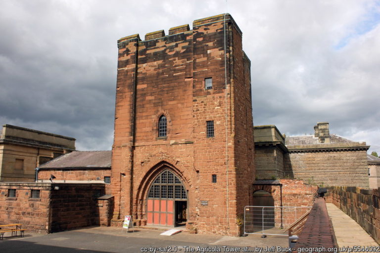
Hugh also refounded the abbey of St Werburgh as a Benedictine house in 1093, and it is that building – not the castle – that dominates the city today. It escaped destruction at the Dissolution because Henry VIII made it the cathedral of a new diocese in 1541. The 12th-century Agricola Tower survives from the castle, with 13th-century wall paintings in its chapel uncovered during conservation work in the 1990s.

The Rows and the walls
The Rows are Chester’s one genuinely unique contribution to architecture: a continuous covered walkway at first-floor level with shops behind it, and a second tier of shops at street level below. Timber dating puts the earliest at the 13th century and the first written mention comes in 1293. Why they exist is still argued over – a response to the great fire of 1278, buildings raised on Roman rubble, or a defensive measure against Welsh raids are the three main theories.
The walls reached roughly their present form in the same period. The Normans had extended the Roman circuit west and south to enclose the castle, and by the middle of the 12th century the loop was essentially complete. Towers went up along it through the medieval centuries – the Water Tower, Bonewaldesthorne’s Tower and Morgan’s Mount among them – and the four gates carried the main roads out to Wales, the north, the river and the sea.
 Photo: Jeff Buck (CC BY-SA 2.0) via Wikimedia Commons
A port, and the guilds
By 1195 ships from Aquitaine, Spain, Ireland and Germany were unloading at Chester, and for much of the Middle Ages this was the principal English port for Ireland. That trade paid for the buildings, and it supported the trade guilds – bakers, tailors, goldsmiths, drapers – who ran much of the city’s working life.
The guilds also staged the Chester Mystery Plays, a cycle of biblical dramas performed on wagons through the streets, each play sponsored by a different trade. Chester held out longer than anywhere else in England when the Elizabethan church suppressed the cycles as popery: the plays ran here until 1578, the last of the great English cycles to go. They were revived for the Festival of Britain in 1951 and have been performed in the city every five years since.
The river turns away
The problem that would define the next four hundred years began quietly.
The Dee was never an easy river, and from the late Middle Ages it silted steadily. Ships grew larger while the channel grew shallower, and the port retreated downstream – first to Neston, later to Parkgate, each time a little further from the city that owned the trade. Chester spent centuries trying to engineer its way out of the problem and never managed it.
What finished the argument was Liverpool. By 1840 the Mersey had taken the Irish trade outright and Chester’s working harbour was over. It was an economic disaster and, in the longer run, the reason the city looks the way it does: a place with no trade and no industry has no reason to demolish its old buildings.
The Civil War siege, 1644–46
Chester was the last major Royalist city in the north-west, and it was starved out.
Chester declared for the King, and its position mattered: it was the port through which Royalist reinforcements from Ireland would have to come. Parliamentary forces closed in, and the siege proper tightened from September 1645. On 22 September a cannon breached the wall near the amphitheatre – you can still see where the repair was made.
Two days later Charles I stood on the tower on the north wall, ever since known as King Charles’ Tower, and watched his cavalry destroyed at the Battle of Rowton Heath a couple of miles away. He left the city the following day. The garrison held out through the winter on starvation rations, refusing terms nine times, and finally surrendered in February 1646. The city was left impoverished, its trade already failing and its walls damaged – the end of medieval Chester in every sense that mattered.
The base for the Welsh wars
Chester’s medieval prosperity is usually told as a story about the port and the guilds, but for two decades in the late thirteenth century the city was also a war machine. Edward I ran both his Welsh campaigns from the Cheshire side of the border, and Chester was the mustering ground: labourers, masons, carpenters and diggers were gathered here each spring and taken west for the building season, along with the timber, iron, lead and money that turned a conquest into stone.
What that produced is still standing, and it is closer than most visitors realise. Conwy — begun in 1283, castle and town walls together, for something near £15,000 — was laid out as a single planned English town on Welsh ground, and the men who built it walked out of Chester to do it. Richard the Engineer, who also worked on the choir of Chester Cathedral, supervised the western side of Conwy’s walls under Master James of St George, Edward’s chief architect. Beaumaris and Harlech followed the same pattern, financed and supplied through the same border machinery, and at Caernarfon the same idea was built on the largest scale of all — a castle and a walled town as one scheme, its polygonal towers and banded masonry usually read as a deliberate echo of the walls of Constantinople. The contrast with what all this replaced is stark: Dolbadarn, the castle the princes of Gwynedd built at Llanberis, is a single round tower on a rock — effective, cheap, and entirely without the political theatre.
It is a useful corrective to the idea of Chester as a purely commercial city. For a generation it was the hinge of English policy in Wales — which is also why the earldom mattered so much, and why Richard II’s charter of 1398 could call it a principality. If you want to see what that Chester was actually paying for, Conwy Castle is about an hour west and largely unaltered.
Continue
Next: Georgian & Victorian Chester. Back to Roman Chester or the history overview. To see the medieval city, the attractions page covers the walls, the Rows, the Cathedral, Chester Castle and St John’s.
Photographs credited beneath each image where sourced externally. Sourced images used under Creative Commons licences via Wikimedia Commons.