
Chester history · before AD 74
Before the Romans
There is almost nothing prehistoric under Chester itself. The interesting question is why — and the answer is out on the Cheshire plain.
Every other page in this section starts with something you can go and look at. This one has to start with an absence. Despite a century and a half of excavation inside the walls, very little evidence of pre-Roman occupation has ever been found on the site of Chester.
That is a genuine finding rather than a gap in the digging, and it tells you something useful: the Romans did not take over an existing British town. They chose an empty riverside spur, and they chose it for reasons that had nothing to do with who already lived there.
The short version
The empty spur
What the Romans found in AD 74.
The fortress was placed on a low sandstone ridge in a bend of the Dee, at the lowest convenient crossing of the river and at the head of a navigable estuary. Those are military and logistical criteria, and they had been served perfectly well until then by nobody living there at all.
Writing up the evidence to the year 2000, the Victoria County History put it plainly: little evidence of pre-Roman occupation of the site had come to light, although local archaeologists thought significant Iron Age activity in the vicinity was likely. That is still roughly where the argument stands. There was almost certainly farming and movement through the area. There was no town, no hillfort and no obvious ritual centre where Chester now sits.
Beeston Crag: the real prehistoric site
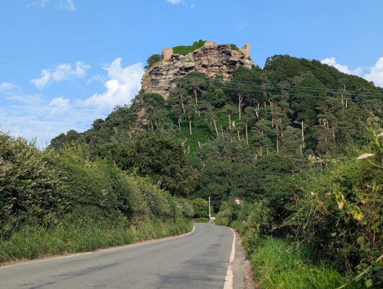 Photo: TCExplorer (CC BY-SA 2.0), via Wikimedia Commons
Eleven miles south-east, and worth the drive
If you want to stand somewhere prehistoric near Chester, go to Beeston. A crag of red sandstone stands 350 feet clear of the plain, and people have been using it for about six thousand years. Pits of the fourth millennium BC show Neolithic occupation or gathering, and flint arrowheads have been recovered from the summit.
The Bronze Age is better represented still. A rampart on the crag has been dated to between about 1270 and 830 BC, and seven circular buildings belong either to the late Bronze Age or the early Iron Age. The finds suggest specialist metalworking — this was a place where bronze was made, not merely used. The later Iron Age hillfort reused the same defences, and in the 1220s Ranulf de Blondeville, 6th Earl of Chester, reused them again when he built Beeston Castle on his return from crusade. Three thousand years of people agreeing that this is the right hill.
Who lived here
The Iron Age people of the Cheshire plain were probably the Cornovii, whose territory is usually put across Shropshire, Cheshire and the Welsh border, with the Deceangli to the west across the Dee. Neither is well documented. They left no coinage of their own, no great oppidum has been identified in Cheshire, and what we know comes mostly from Roman writers describing them from the outside.
What Cheshire did have was salt. The brine springs at what became Middlewich, Northwich and Nantwich were exploited long before the Romans arrived and were among the reasons the region mattered to them afterwards. Salt preserved food, and whoever controlled it controlled something everyone needed.
The coast that has moved
 Photo: Rept0n1x (CC BY-SA 3.0), via Wikimedia Commons
A different shoreline
One reason prehistoric Cheshire is hard to read is that the coast is not where it was. The Dee estuary has silted steadily since the Roman period and dramatically since the Middle Ages, and the Wirral shoreline of two thousand years ago lay well inside the present line of saltmarsh.
The Wirral does hold one exceptional site. At Meols, on the north coast, erosion has been turning up metalwork and coins for two centuries — material running from the Iron Age through the Roman period and on into the Middle Ages, including coins from the Mediterranean world. It looks like a trading beach, used long before Chester existed and for the same reason Chester later worked: this is where the Irish Sea meets a route inland.
Why the absence matters
It is tempting to fill a blank with speculation, and Chester has had plenty over the years — a supposed British settlement, a druidic centre, a pre-Roman crossing town. None of it stands up. The honest reading is that the Romans founded Chester on a site that had no significant settlement, which makes it unusual among major English cities and helps explain the extreme regularity of its street plan.
York, Lincoln and Colchester all sit on or beside places that mattered before the legions came. Chester does not. Every layer of this city, from the Cross to the walls to the Rows, sits on a decision taken by a Roman surveyor in the mid-70s AD about where to put a fortress.
Where to see prehistoric Cheshire
Beeston Castle (English Heritage, about 25 minutes by car) is the essential visit: the Bronze Age and Iron Age defences, an outstanding medieval castle, and one of the widest views in England. The Grosvenor Museum in Chester holds the local prehistoric finds alongside its much larger Roman collection. Meols is on the Wirral coast, about 40 minutes away; there is nothing to see on the ground, but the finds are in the Museum of Liverpool.
For the landscape itself, the Sandstone Trail runs 34 miles along the ridge from Frodsham to Whitchurch and passes directly under Beeston. It is the best way to understand why prehistoric Cheshire lived on the high ground and left the wet plain alone.
Keep reading
Chester’s history in order, from the fortress to the present day.
Roman Chester · Saxon and Viking Chester · All history
Photographs are reproduced under Creative Commons licences; the photographer and licence are credited beneath each image.
Hero photograph: TCExplorer (CC BY-SA 2.0), via Wikimedia Commons