
Stand on the Old Dee Bridge and it is hard to credit. The river below is shallow and quiet, yet ships from Spain, France and Ireland once tied up beneath the city walls, and the Water Tower, built in the 1320s to guard the harbour, now stands about 180 metres from the water.
This is one of the stories that best explains Chester: a city shaped by a restless estuary, by the people who kept working to tame it, and by what Chester made of itself along the way.
The port at a glance
- c.1195Ships from Aquitaine, Spain, Ireland and Germany unload wine and load salt, hides, cloth and lead
- c.1570The New Haven at Neston becomes the anchorage for larger ships
- 1737Nathaniel Kinderley’s New Cut opens along the Welsh shore
- c.1740–1768The Old Crane and then the New Crane wharves built along Kinderley’s new channel
- 1800sLiverpool leads the deep-sea trade, while Chester’s quays stay busy with coastal, Baltic and trans-shipped cargoes
- 2021Chester becomes the first canal and river system designated a Heritage Port
When Chester was a great port
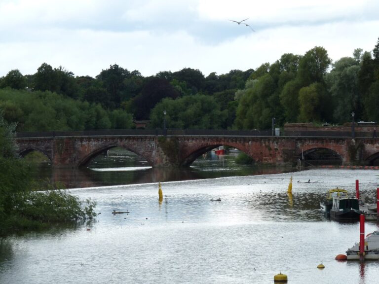 Photo: Chris McKenna (CC BY-SA 3.0) via Wikimedia Commons
From Roman Deva to the twelfth century
The Romans chose Chester partly for its river. Their harbour lay along the western edge of the fortress, on ground that is now the edge of the Roodee; a stretch of Roman masonry there is listed by Historic England as part of a quay wall, though some archaeologists now read it as a defensive wall with timber jetties beyond.
By about 1195 ships from Aquitaine, Spain, Ireland and Germany were unloading wine at Chester and taking away salt, hides, cloth and lead. Through the Middle Ages the river channel moved west and the quays followed it. Into the sixteenth century ships could still unload near the Watergate, and the Water Tower was built out into the river to defend them.
A shifting, silting estuary
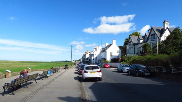 Photo: Colin Park (CC BY-SA 2.0) via Wikimedia Commons
Neston, then Parkgate
The Dee is a shallow estuary with a huge tidal range and a heavy load of sediment, and its channels were always on the move. By the sixteenth century larger ships could not reliably reach the city, so they anchored downstream and sent their cargoes up in smaller boats.
Around 1570 the New Haven at Neston came into use for larger vessels, and from the 1680s the anchorage moved further down the Wirral shore to Parkgate. A regular passenger packet to Ireland sailed from Parkgate from 1686, and its passengers included John Wesley and Handel.
The New Cut and Chester’s Georgian revival
Chester did not give up on its river.
In 1737 Nathaniel Kinderley’s New Cut opened: a straight channel along the Welsh shore, designed to hold the tide and scour away the silt. The River Dee Company was formed to run it, and trade came back to the city. The new channel began at Wilcock’s Point, where the railway viaduct now crosses the river, and Chester’s new quays were built along it: the Old Crane wharf from around 1740, then New Crane Wharf from the late 1760s, which survives today. New Crane Street was laid out to carry goods into town, and the older inner port below the castle, along what is now Castle Drive, stayed in use into the early nineteenth century.
The shipyards were busy too. The Napoleonic Wars kept them working, and canals built between the 1770s and the 1830s linked Chester to the Midlands and the Mersey.
Chester and Liverpool: neighbours as well as rivals
Liverpool’s rise was gradual. Its first enclosed wet dock was begun in 1715 and finished by the 1720s; before that, ships on the Mersey had to anchor offshore and unload into small craft, while Chester had riverside quays to land at. It took most of the eighteenth century, and a great deal of land reclaimed from the Mersey, for Liverpool to build the docks that gave it the lead. Meanwhile the New Cut was poorly maintained and the channel kept shoaling, so by the nineteenth century most of the deep-sea trade was going to the Mersey.
Chester did not switch off. The two ports worked together, with Atlantic goods such as sugar, tobacco and cotton trans-shipped from Liverpool to Chester and back. Chester’s quays handled Baltic timber and grain, ores, Welsh slate and stone, and a great deal of coal, supplying the city’s iron and brass foundries, lead works and chemical works. Mersey flats were still being built at Chester around 1850, coastal steamers kept calling at Crane Wharf until the 1930s, and the Chester and Holyhead Railway, opened in 1848, crossed the river on its viaduct at Wilcock’s Point.
What Chester became
 Photo: David Smith (CC BY-SA 2.0) via Wikimedia Commons
A county town, a resort and a racecourse
As the big ships moved downriver, Chester leaned into what it already did well: markets and fairs, law and county government, shopping for a wide rural hinterland, and welcoming visitors.
The Roodee, the old riverside meadow below the walls, has hosted racing since 1539, making Chester Racecourse the oldest still in use. Today the river is the city’s playground, with boat trips from the Groves and rowing on the reach above the weir.
Seeing it today
A short walk that follows the river’s story, in order.
- The WatergateNamed for the river that once lapped outside it. Walk the walls north-west from here.
- The Water TowerBuilt into the river in the 1320s and now standing on dry ground, joined to Bonewaldesthorne’s Tower by its spur wall.
- The Roman quay wallLook down from Nuns Road on the east side of the Roodee to see the listed Roman masonry.
- The Old Port and New Crane WharfWalk past the racecourse and under the railway viaduct to the surviving Georgian quay and warehouse, linked to the Groves by the riverside promenade.
- The Old Dee Bridge and weirThe limit for seagoing ships, and the best place to picture the medieval river.
- Parkgate, on the WirralA half-day trip. The old seafront promenade now looks out over saltmarsh where the packet boats once lay.
Chester, the UK’s first canal and river Heritage Port
Thanks to Chester Civic Trust, the Inland Waterways Association and Cheshire West and Chester Council, Tower Wharf, the Dee Branch canal, the tidal river and the Old Port are now recognised as one connected story, with work continuing to bring them back to life.
The Welsh side of the river
The Dee is a shared river, and its trade grew on both banks. Kinderley’s New Cut was dug on the Welsh side because that was where the deep water ran, and Flintshire quays grew up alongside Chester’s. Lead from the Flintshire mines and from the Minera lead mines above Wrexham went out through Chester and the Flintshire quays alike, and in the nineteenth century the railway along the coast helped turn fishing villages into Rhyl, Colwyn Bay and Llandudno.
It is one economic story with a border running through it. Guides to the North Wales coast cover the harbours and resorts at the far end of a story that begins on the river at Chester.
Sources and further reading
- The economy, 1762–1840, A History of the County of Chester vol. 5 pt 1 (Victoria County History, 2003)
- Economy and society, 1662–1762, A History of the County of Chester vol. 5 pt 1 (Victoria County History, 2003)
- Railways, A History of the County of Chester vol. 5 pt 2 (Victoria County History, 2005)
- Malcolm L. Reid, The Early Modern Port of Chester, Journal of the Chester Archaeological Society new series 82
- Chester Heritage Port Designation Document (Chester Civic Trust and IWA, 2021)
- Part of a Roman quay wall, the Roodee, Historic England list entry 1375955
- Tom Welsh, on Chester’s inner port along what is now Castle Drive, Cheshire History no. 66, pp. 58–81
- Richard Martin, Ships of the Chester River (2018): over 600 vessels launched on the Dee after 1800, and the families who built them
- Liverpool’s Old Dock, National Museums Liverpool
Spotted something we should correct? Local historians have helped improve this page, and we welcome more corrections. Get in touch through the contact link at the foot of the page.
Keep reading
Medieval Chester · Tudor and Stuart Chester · Georgian and Victorian Chester · The Roodee · All history
Photographs are reproduced under Creative Commons licences; the photographer and licence are credited beneath each image. Hero photograph of the River Dee at the Groves via Wikimedia Commons.